East West Traverse of Croagh Patrick from Westport Area
Westport, Ireland
Trip Type: Hiking & Camping
Duration: 6 hours
The East West traverse of the Reek is a beautiful six-mile (ten kilometre) hike that starts on the Western Way – a rugged trail that runs more or less in a north south direction for almost one hundred miles – and ends at Ben Goram, the most westerly summit on the Croagh Patrick ridge. Along the way, you will have the islands of Clew Bay on your right, and the Southern Wilderness stretching into Connemara on your left.
More About This Activity All Hiking & Camping →
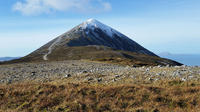
The East West traverse of the Reek is a beautiful six-mile (ten kilometre) hike that starts on the Western Way – a rugged trail that runs more or less in a north south direction for almost one hundred miles – and ends at Ben Goram, the most westerly summit on the Croagh Patrick ridge. Along the way, you will have the islands of Clew Bay on your right, and the Southern Wilderness stretching into Connemara on your left.We ascend to the first peak, known as Croagh Patrick East Top or Crott Mountain (500 metres), that affords excellent views of Westport and the surrounding area. Following the ridge opens up a stunning vista that consists of Clew Bay and the Nephin mountain range to the north, and the Partry and the mysterious Sheeffry mountains (from Gaelic: Cnoic Shíofra, meaning “hills of the wraith”) to the south.
The eastern summit of Croagh Patrick affords wonderful views of Westport and the surrounding area. Now we are on the ridge that will undulate fairly gently over two more ‘peaks’ before reaching the actual top of the Reek – Teevenacroughy (487 metres) and Lugnademon (510 metres).
The main Croagh Patrick trail, or Pilgrims Path, is joined at the shoulder of the Reek, and from here we follow the path for several hundred yards before tackling the actual summit cone of the mountain. This is the most demanding part of the trek, and some care is required as we clamber over the stony ground. Once on top, we can relax near the tiny church built in 1905, and prepare for the gradual descent to the western slopes, which offer views as far away as the Twelve Bens of Connemara, and the offshore islands of Inishbofin and Inishturk on a clear day. A final rise leads to the top of Ben Goram, at the far western end of the ridge, followed by a descent to Kilsallah and back to our starting point.
.
Total Distance: 10 kilometres (6 miles)
Terrain: Challenging – shale on summit cone
Typical Time: 4-6 hours with stops
.
« Go Back